varoth
- 180 Posts
- 65 Comments
 1·4 days ago
000 WTNT32 KNHC 300239 TCPAT2
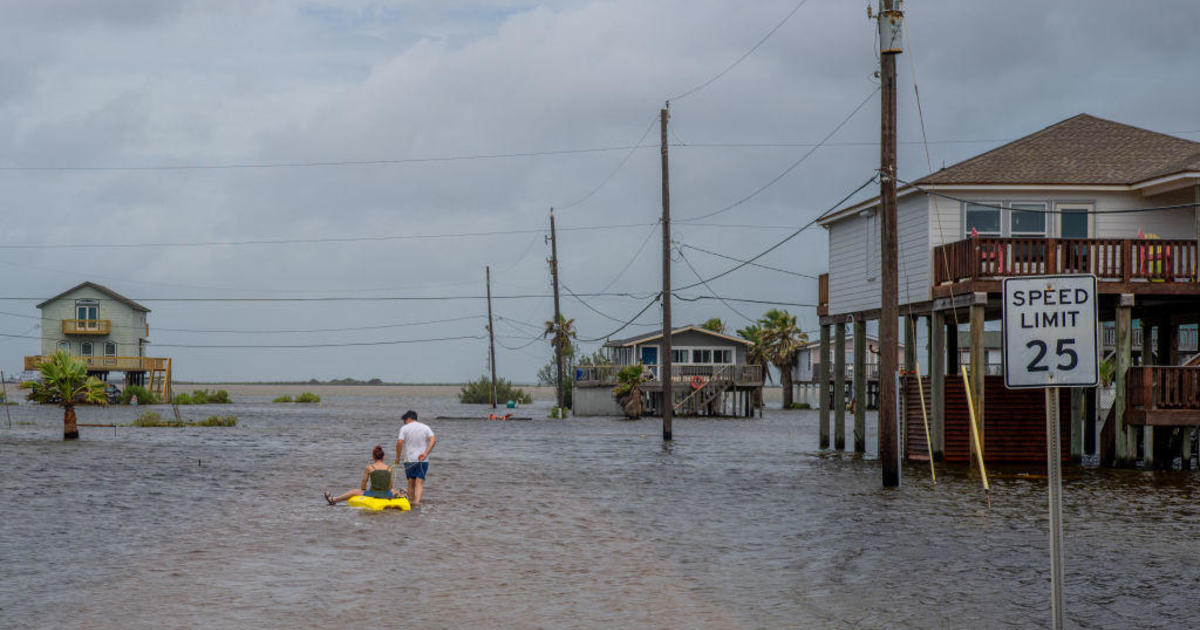
BULLETIN Hurricane Beryl Advisory Number 6 NWS National Hurricane Center Miami FL AL022024 1100 PM AST Sat Jun 29 2024
…BERYL STILL RAPIDLY INTENSIFYING… …EXPECTED TO BRING LIFE-THREATENING WINDS AND STORM SURGE TO THE WINDWARD ISLANDS AS A MAJOR HURRICANE…
SUMMARY OF 1100 PM AST…0300 UTC…INFORMATION
LOCATION…10.4N 51.2W ABOUT 595 MI…955 KM ESE OF BARBADOS MAXIMUM SUSTAINED WINDS…85 MPH…140 KM/H PRESENT MOVEMENT…W OR 280 DEGREES AT 20 MPH…31 KM/H MINIMUM CENTRAL PRESSURE…986 MB…29.12 INCHES
WATCHES AND WARNINGS
CHANGES WITH THIS ADVISORY:
None.
SUMMARY OF WATCHES AND WARNINGS IN EFFECT:
A Hurricane Warning is in effect for…
- Barbados
- St. Lucia
- St. Vincent and the Grenadine Islands
- Grenada
A Tropical Storm Warning is in effect for…
- Martinique
- Tobago
A Tropical Storm Watch is in effect for…
- Dominica
A Hurricane Warning means that hurricane conditions are expected somewhere within the warning area. A warning is typically issued 36 hours before the anticipated first occurrence of tropical-storm-force winds, conditions that make outside preparations difficult or dangerous. Preparations to protect life and property should be rushed to completion.
A Tropical Storm Warning means that tropical storm conditions are expected somewhere within the warning area within 36 hours.
A Tropical Storm Watch means that tropical storm conditions are possible within the watch area, generally within 48 hours.
Interests elsewhere in the Lesser Antilles should closely monitor the progress of Beryl. Additional watches and warnings may be required tomorrow.
For storm information specific to your area, please monitor products issued by your national meteorological service.
DISCUSSION AND OUTLOOK
At 1100 PM AST (0300 UTC), the center of Hurricane Beryl was located near latitude 10.4 North, longitude 51.2 West. Beryl is moving quickly toward the west near 20 mph (31 km/h). A continued quick westward to west-northwestward motion is expected during the next few days. On the forecast track, the center of Beryl is expected to move across the Windward Islands late Sunday night and Monday.
Maximum sustained winds have increased to near 85 mph (140 km/h) with higher gusts. Rapid strengthening is forecast over the next day or so, and Beryl is expected to become a dangerous major hurricane before it reaches the Windward Islands.
Hurricane-force winds extend outward up to 15 miles (30 km) from the center and tropical-storm-force winds extend outward up to 70 miles (110 km).
The estimated minimum central pressure is 986 mb (29.12 inches).
HAZARDS AFFECTING LAND
Key messages for Beryl can be found in the Tropical Cyclone Discussion under AWIPS header MIATCDAT2 and WMO header WTNT42 KNHC.
WIND: Hurricane conditions are expected in the hurricane warning area beginning Sunday night. Devastating wind damage is expected where the eyewall of Beryl moves through portions of the Windward Islands.
Tropical storm conditions are expected in the tropical storm warning area starting Sunday night, making outside preparations difficult or dangerous.
Tropical storm conditions are possible within the watch area starting Sunday night.
Wind speeds atop and on the windward sides of hills and mountains are often up to 30 percent stronger than the near-surface winds indicated in this advisory, and in some elevated locations could be even greater.
STORM SURGE: A life-threatening storm surge will raise water levels by as much as 5 to 7 feet above normal tide levels in areas of onshore flow near where Beryl makes landfall in the hurricane warning area. Near the coast, the surge will be accompanied by large and destructive waves.
RAINFALL: Hurricane Beryl is expected to produce rainfall totals of 3 to 6 inches across Barbados and the Windward Islands Sunday night into Monday. This rainfall may cause flooding in vulnerable areas.
For a complete depiction of forecast rainfall and flash flooding associated with Hurricane Beryl, please see the National Weather Service Storm Total Rainfall Graphic, available at hurricanes.gov/graphics_at2.shtml?rainqpf
SURF: Swells generated by Beryl are expected to reach the Windward and southern Leeward Islands by late Sunday. These swells are likely to cause life-threatening surf and rip current conditions. Please consult products from your local weather office.
NEXT ADVISORY
Next intermediate advisory at 200 AM AST. Next complete advisory at 500 AM AST.
$$ Forecaster Papin


 1·29 days ago
Yep, pretty much. They’ll never issue a real fine.
Agreed. Corporations should not be allowed to own housing. It has zero benefits for the public and little to no drawbacks for the corporation.
 5·29 days ago
Seriously. They act like it’s 1924 not 2024, when ~$3,000 was the equivalent of ~$55,000 today.
 5·29 days ago
Gentrification: the process whereby the character of a poor urban area is changed by wealthier people moving in, improving housing, and attracting new businesses, typically displacing current inhabitants in the process.
It literally is gentrification. And yes they are NIMBYs too. It’s both. It’s the same coin.
Pretty much. Gentrification in action. They’re pricing out workers who work these jobs and then the rich people who move in pitch a fit about how there’s long waits and “no service” and how “no one wants to work anymore.” You all did this to yourselves. You chased away the workers. If you have a problem with the environment you created, perhaps you should stop doing that or go work these “great” jobs yourselves?
 134·29 days ago
Good. Let’s issue warrants for all current and former presidents too as they’re all war criminals.
I hope they fine all of them trillions and jail the top level people. They shouldn’t be allowed to get away with this BS. There’s been rampant price gouging, fixing, and collusion going on in this country for a long time now across industries and it sure would be nice if someone would do something to stop it.
Right? There’s people still spouting that “all of that money from the pandemic” is somehow still sustaining the lives of thousands and thousands of people 4 years later.
 1·29 days ago
Yeah that is some odd phrasing on their part.
Seriously. I lived in NOVA briefly many years ago and it took me legit over an hour to go 5 miles on the interstate. Tolls do nothing to alleviate congestion and only punish people by making them pay more money for no reason other than to make the toll collectors profit.
That’s correct. Hampton Roads is a major military area, particularly for the Navy and because of that when the water crossings were built, they wanted to use tunnels specifically because they didn’t want the harbor to be blocked during a war. The original version of the Hampton Roads Bride Tunnel (HRBT), opened in the 1950s, so World War 2 was likely still pretty fresh in people’s minds.
 16·4 months ago
There is no “God’s Law,” because there is no God. God is a figment of society’s imagination. Santa Claus, the Easter Bunny, ghosts, aliens, Bigfoot, and the Loch Ness Monster are all more real than “God.”
Also, we don’t have a state religion despite these fuckwads’ desperation for a christofascist theocracy. Can’t they just all fuck off to some uninhabited island and live out their stupidity there?
Don’t you just love rent/housing? Oh, sorry you don’t make enough money to qualify for a mortgage. But hey you can pay $1,500/month+ to pay your landlord’s mortgage!
It’s almost like we have no money and don’t have a choice because having ridiculous luxury items like FOOD, requires you know, money.
 1·4 months ago
Hmm, interesting. Maybe I should try that sometime.
On lemmy.world you click the little clipboard looking thing underneath your community’s name on the right side of the screen.

 730·4 months ago
Where exactly did I say to vote for Trump?
My saying doing the same thing over and over and over was perhaps too vague. I meant we shouldn’t keep voting for Republicans AND Democrats and expecting them to fix things because neither have any interest in doing so. They only care about making themselves rich and their donors rich.
Venus? Neptune? Alpha Centauri?
You’re welcome!
I hope you are able to stay safe.